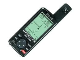
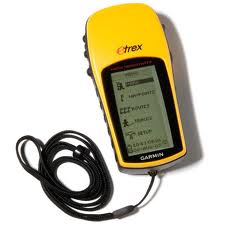
Above is pictured a Magellan 315 GPS and a Garman eTrex H, both are examples of a typical Navigation GPS there are many different designs and makes but all unit work roughly the same the only differences are the naming and layout of screens and such, a Navigation GPS dose not show roads street addresses but can display compass bearings latitude and longitudes and some modals can even show Topographical information (Topographic Maps). It is possible that you can get a unit that will do Vehicle and Navigation as well as Marine Navigation but the more complicated you go the higher the price tag. A Navigation GPS is designed for Someone who understands mapping and Compass’s it is not something every one can use right off the sheath, it is recommended that you familiarise you sleuth with your GPS well before you take it on a trip. In an emergency you can give the Emergency services your position as a WGS84 or a latitude and longitude make shore they understand which system you are using. They may ask for cross street give them one if you can.

| Pros |
Cons |
| Small and light |
Can use a lot of power from batteries |
| Will give you Lat and long as well as compass and WSG84 functions |
Mid/High Equipment cost |
| Easy to obtain |
Can be hard to use |
| Work every were you can see a good amount of open sky |
Must be moving to get compass to work (unless unit has flux gate Compass) |
GPS Screens
The Status Screen
The Status screen gives us an idea of the number as well as the positions of the available satellites and the power and type of navigation system being used. All GPS’s have some form of this screen
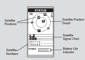
Satellite Positions: Where the satellite is located relative to your position. You are always in the centre of the inner ring.
Satellite Numbers: Identifies the satellite shown on the chart and on the Satellite Position Graph.
Battery Life Indicator: Shows approximate remaining battery life for batteries in the receiver.
Satellite Signal: Chart Displays satellite signal strengths shown in grey for weak signals and black for strong signal on a black and white screen. When the receiver first tracks a satellite, the strength bar will not be solid black until enough data is collected. This takes about 30 seconds if uninterrupted signal.
Graph: The two circles indicate satellite elevation, the outer circle represents the horizon and the inner circle represents 45 degrees from the horizon. The centre of The circle is 90 degrees.
Position Screen
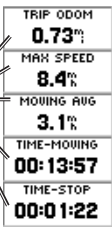
The Position screen shows the current location of the unit as well as Speed, time, date and lots of other useful information, all Navigation GPS have this ability
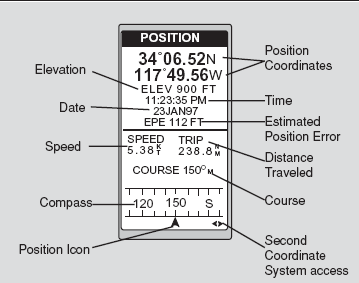
Position Icon: Your current position on the compass. Acts like the north on a compass used to take a bearing. (Note you must be moving) if you do not have a flux gate compass installed
Estimated Position Error: Displays the accuracy of the Position, this can be some time up to 100 meters or just 1, this roughly means that the Position is with in 1 meter if the Estimated Position error is 1
Second Coordinate System: This is a menu that is normally set by the user it is recommended that all GPS second Coordinate systems be set to WGS84 which is the world wide Coordinate system, on modem maps the coordinates will mach up.
Map Screen
The map screen is used to show us were we have been and how close you are to waypoints and such, this can also sometimes show topographic data or road maps as well
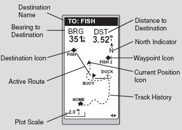
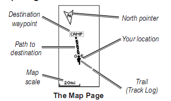
Active Route: Indicates the direction required to reach your destination. Plot Scale Can be changed
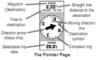
Pointer Screen
The pointer screen helps guide you to a destination. When navigating towards a destination. The pointer screen shows the name, the distance, Time to go and a direction arrow in the compass ring.
The compass ring reflects your heading (direction of movement). To navigate, walk in the direction the arrow is pointing. When the arrow is pointing at the moving direction line or steering indicator your destination is ahead